Showing posts with label expedition. Show all posts

Murray River Paddle 2016 Day 49 & 50 Rest Day then Blanchetown to Walker's Flat


Day 49 & 50: 212km Walker's Flat 4th Dec 2016

Blanchetown Hotel - Ski Club - Expeditioners - Flood wave attenuation - Floodplain - Fisheries - Cliffs - Cockatoos - Rain - Shacks - Gorge - Travellers


Rest Day then Blanchetown to Walkers Flat

Sometimes the unexpected happens. I found myself a guest at the ski club table at the Blanchetown hotel. Rob and Sally, my neighbors at the caravan park, had invited me to join their family for dinner. Rob told me that in South Australia there has only recently been limits set on how much water can be pumped from aquifers for irrigation and that the underground streams that run through the limestone beneath the farms are beginning to run dry. No wonder with so many centre pivots and few controls. Rob and Sally are from Mt Gambier. They come to the lower Murray to ski because the river is wide and it's not crowded, and because the ski club has great programs for kids.

Earlier in the afternoon, I met Warren, a Murray Expeditioner from 1991 - before there were mobile phones. He would find a payphone in towns he passed through to let his wife know all was ok. He couldn't look up the weather, or use google maps... Although it was not all that long ago, much has changed.

Warren gave me a hand to carry things down to the boat and at 8:30 I was off, ready for the Lock opening time. Barry, the lock master saw me coming and had the gates open by the time I was there. He said the peak was predicted to arrive in a few weeks, but that by the time the water reached Blanchetown only about 80,000 megalitres a day was expected, the rest being used by irrigation pumps, or absorbed into the flood plains. Barry was upset about the Murray cod deaths from blackwater upstream and asked why more water could not be released from the Darling (Menindee Lake) to provide a safe place for the fish to shelter in until the black water passes. We talked about investing in the health of the river. Barry told me that there is only one fisheries officer for all of the South Australian rivers. That person is expected to patrol the whole of the South Australian Murray, the Onkaparinga and the Torrens rivers.

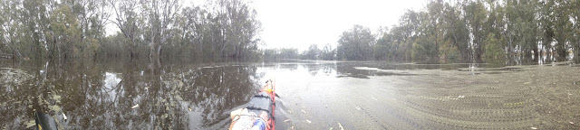
The weather was calm when I left the caravan park, but by the time I left the lock chamber it had begun to drizzle. The drizzle stayed with me. By the afternoon, it had turned into a soaking rain. I pulled out my wet weather gear and continued on, toasty warm, despite everything around me being so wet. I had looked forward to the predicted 38 deg C and strong Northerly winds. It would have been the first time I would have had a day of tailwinds in the whole trip. Neither happened. The overcast skies kept the temperature down and the wind continued gusting from the southwest - straight into my face. Waves crashed over the front deck slamming into my water bottles, my second line of defence.

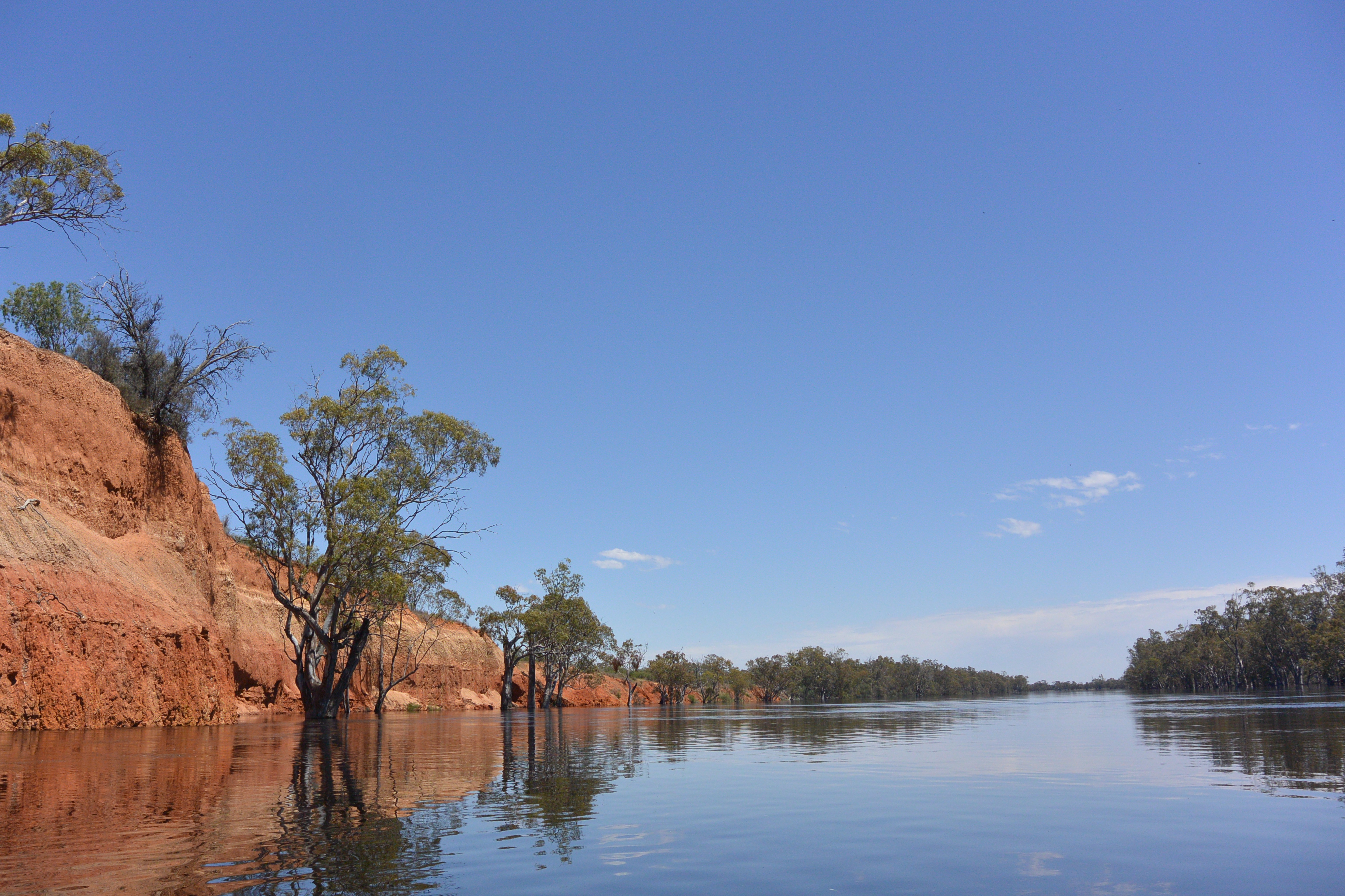
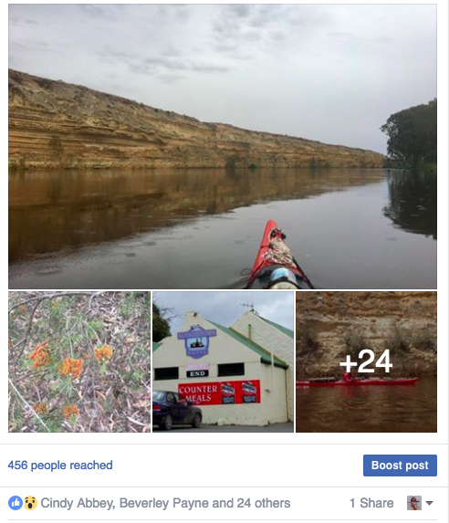
The cliffs downstream from Blanchetown are the biggest on the Murray and where the river runs alongside them, they have vertical faces. Big Bend is made up of two curves, one curving west and one curving east. Each runs for about 5 kilometers and both were filled with cockatoos. The cockatoos occupied small hollows and when I approached flew noisily into the air. At first I thought that they were after minerals from the cliff face, but on looking more closely, I saw that they were in pairs. They appear to be nesting in the rock rather than tree hollows. The cliffs do not have the thick sandstone layers that those upstream have, making them harder and more resistant to erosion.

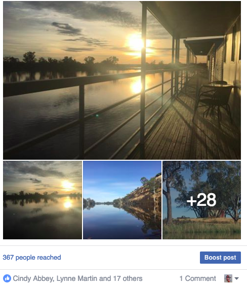
Once the rain cleared for the last hour or so of today's eight hour paddle, the colors had a new crispness and depth. It was as though someone had hit the enhance button. When the sun broke through the clouds, it became steamy and hot. I shed my rain jacket and applied sunscreen. People began to get out into the water again. A ski boat zoomed past, followed by a traditional clinker hulled river launch. Interestingly the rear waves from the older boat went on for kilometers. I think it had something to do with the hull design.

Farms and properties along the river continued to be developed as shack areas. These holiday homes are called shacks because their original purpose was as places to fish and hunt from to help city people out during the depression years. The right to maintain a 'shack' is written in law. A few original shacks remain, little more than corrugated iron bush huts, but most shacks are a far cry in both design and purpose. Newer shacks are usually 2 story, with verandas and lounges from which to enjoy the river. Many modify the bank using terraces and retaining walls. All have removed the understory vegetation and replaced it with lawn.

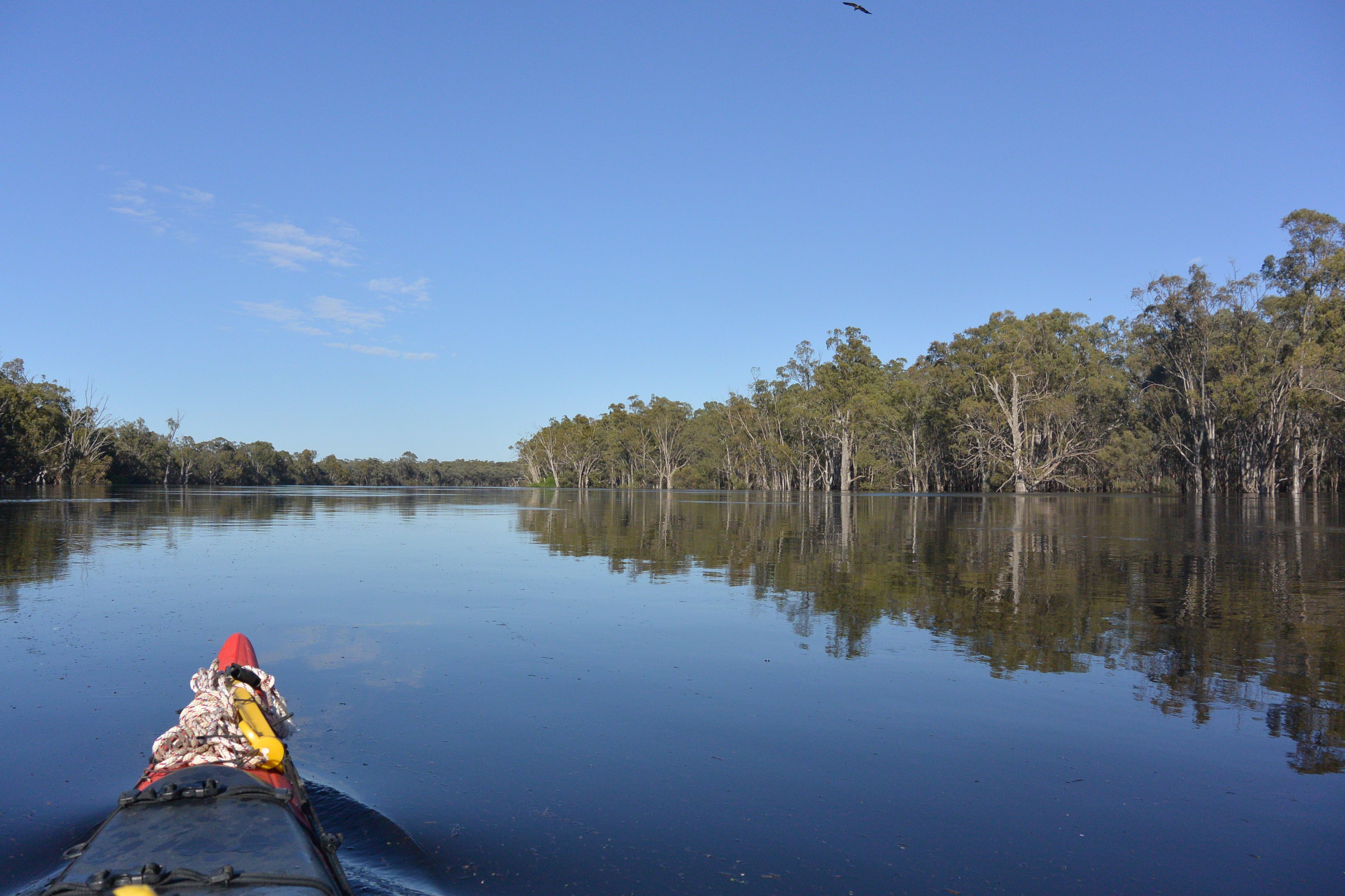
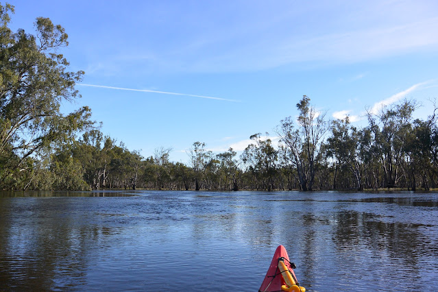
On this section of the river, the ancient Murray Gorge, through which the current Murray flows is very narrow, little more than a kilometer. Old river beds form billabongs running parallel to the river, resulting in a rich and varied habitat for both animal and plant life, all the time contrasted by the arid hills beyond. Bends run for up to 10 kilometers and the river is wide. It doesn't take much for the wind to whip up waves to test a weary paddler.

Coming into Walkers Flat I found a spot next to a German couple, Carsten and Christiana, who have been traveling the world in their expedition grade camper for 4 years. Over a few beers I told them things I thought would interest of the Murray and listened to their stories of South America, Asia, Antarctica and Australia.

Tomorrow I make for Younghusband, after making time to resupply at the Walkers Creek Shop. All the time I am getting closer to the sea. Not many more days now.


Murray River Paddle 2016 Day 48 Morgan to Blanchetown


Day 48: 276 km Blanchetown 2nd Dec 2016

Apostle birds - Morgan - Houseboats - Fellow kayakers - Blackwater - Floods - Murrumbidgee River - Itldoo Station - Shacks - Crooks Landing - Halvorsen cruiser - Murray Gorges - Ecosystem dynamics - Mosaic - Ted the boat dog


Morgan to Blanchetown

A big thank you to Kev who put me up for the night, laid on dinner, beers and breakfast. Kev is planning to paddle the Murray in Aug next year. He has read all the trip reports he can get his hands on. He has even seen what the trip can do to you... (Clarkies' unique finishing photo may never be upstaged)... and he's still keen to do it. Kev has a backyard full of chooks and apostle birds. There is a constant argument going on as to who’s boss. The apostle birds have adopted Kev, they come up and sit near him and eat from his hands, even though they are wild birds.

Morgan is full of houseboats. The shores are busy places. Sounds of angle grinders, hammers and lawn mowers in preparation for weekend and summer holiday guests. Prime real estate is down by the waterside, with even a shed going for around 300,000. In a twist on the past, places up on the hill, built of solid stone, symbols of wealth in the paddle Steamer times era are a fraction of the price now.
I paddled out of Morgan with Rordon and Dale, two Cairns based paddlers who had come down to paddle the Murrumbidgee River from Gundagai to where it meets the Murray near Boundary Bend. They had to call off their trip at Hay because the black water and the amount of dead stock in the river had made it unpleasant and potentially unsafe for their dog Ted. Ted is a true boat dog. He sits on a mat between the front and back seat of their kayak. Their kayak is the best appointed that I have ever seen. Rordon made it himself from a kit. It is wooden, with fiberglass internal and external layers, roomy and cuts the water beautifully. We paddled the first 10 kilometers together until the appropriately named 'Itlldoo' Station, where they turned around and made their way back to Morgan. Rordon and Dale hope to continue their bidgee paddle once the high water has passed, but enjoyed sharing their memories of their full distance Murray paddle in 2014.

After about 15 km, the shacks (as even the luxury riverside houses are called) finally gave way to bush. Patches of development continued around high ground, which usually still had the historical name of the property whose Landing Paddlesteamers had stopped to trade at in bygone days. Most shacks have lawn down to the water’s edge and many have sprinkler systems set up. I suspect these are to discourage campers and unwelcome boats and their passengers mooring on their property. Looking for a shady place to pull in for lunch, I eventually decided to brave having the sprinklers turned on on me and pulled into Crooks Landing at Ridgeway Station for lunch break. Above me cockatoos are nibbling the seed pods of the River Myalls. A cool breeze was blowing and I soon drifted off to sleep.

There weren't as many boats to photograph today, however there were a few notables. One was a Halvorsen Cruiser, every bit the battleship in pocket format. Another was a modern version of it, with similar lines, but twice as long. There were also little gems, home built paddle steamers and 1920's excursion boats and almost every shack had a tinny.

Probably the most notable thing today was that the river headed due South, with little deviation East or West. I had a 25 km/hr headwind, which kept me on my toes, but as it was not constant, was not too bad. The valley the river runs through is actually the path the ancient Murray. A much bigger river than today's Murray. Geologists have determined that the gorges it cut were 80m deep. The ancient Murray, at first held back by the uplifted land, formed a huge lake, which in spilling, found and enlarged its original path. The deep gorges formed by the ancient Murray are mostly filled with sediment from today's river, creating the gentle gradient we are familiar with in the lower part of the Murray today. At some points, the original gorge is little more than a kilometer wide. Too narrow to meander, the river moves from side to side, leaving billabongs and sand dunes parallel to the main stream. Where the river has not changed its path for thousands of years, flood plains gradually build high enough to support black box. Where it changes more frequently, it erodes these high flood plains, creating low country ideal for red gums with their requirement of frequent flooding. In this way the two habitats can be seen to be competing within the one environment. The floodplain is both building and eroding at the same time. In these narrow gorges this creates a mosaic habitat which is a stark contrast to the arid zone either side.

I reached Blanchetown just after 5pm, half an hour after the last passage was allowed. I could almost have ducked over the barrier rope, however if my kayak had gotten stuck I could have been in real trouble. The better decision was to turn around and return to the caravan park I had seen about 1 km upstream.

The manager had just settled into the pool when I found her. She gave me a nice shady spot with plenty of green grass, near the entrance. I packed my gear into duffle bags and walked it into the park, following eventually with my boat.


Murray River Paddle 2016 Day 47 Waikerie to Morgan


Day 47: 338 km Morgan 1st Dec 2016

Leaving the Murray River Queen - morning light - birds of prey - Big Toulca Flat - Woodcutters Reach - Lock 2 - Undercurrents - Bartels Landing - Floating seeds - Riverleigh Station - Tree health - Tipping points - North-West Bend - Morgan - Paddlesteamers & Wharf


Waikerie to Morgan

I left Waikerie early, before anyone else on the boat was up. The sun was up, it had risen about 5:30 and I had gotten up not long after that. Keeping breakfast simple, a couple of muesli bars, some fruit and a cup of tea, I was ready to push off at 7:30.

The light was beautiful and clear. That together with the smooth surface of the water and still flow out a real spring in my step. Morning light is not as harsh as what it is during the main part of the day. The colours come out. It's when you see just how amazing the bark on red gums can be. Paddling out of town, I passed a long row of houseboats waiting for their next outing, their next passage of discovery.
Whistling Kites have been the most common bird of prey along the river this year. There never used to be so many when I was a kid, but there were more Wedge-tailed Eagles. I don't know what has changed, perhaps they benefit from having fishermen around. Once the cliffs begun, Falcons started to appear. They like to sit at the top of trees on the cliff face and swoop down on their prey, which I imagine, could be any small bird or marsupial. All the more amazing when I saw a Fairy Martin chasing a falcon. It was swooping again and again on the falcon, pecking it on the back. While the falcon tried to get away. Brave little bird.

Again today they were great names like what coverage and Big Toluca Flat and Woodcutter Reach. I guess I shouldn't of been surprised when there weren't very few old trees on Woodcutters Reach.
All along the river I can hear the sounds of people raiding their pumps in preparation for the high water. Occasionally i can hear the voices of fruit pickers drifting down from amongst the orange orchards, however I can rarely see them.

Approaching Lock 2, the navigation pass is open. I can see that the water is at the top of the weir. It splashes up in the air ominously. To go that way would be very dangerous. At Wentworth weir, a tinny was caught in the turbulence behind the wall. The back end went under first, filling the boat with water. Soon the whole boat disappeared, only to resurface 100m downstream. There are signs which slow you where to go to be in the safe passage. You keep right of the green triangle (when going downstream) and left of the red squares. There are some pretty big swirls for the first 200m. If you keep under power (keep paddling) you come through it without too many involuntary course changes.

At Bartels Landing were two old farm houses and in front of them, an eclectic collection of boats. Both farm houses had orange groves behind them as is the old tradition in the area. A little further down stream is a vineyard. In the 1980s when the Australians discovered that there were other beverages besides beer, the Riverland wine industry boomed. It expanded till it seemed that everyone wanted to get into wine. In the late 90s and 2000 the wine industry crashed and with so many suppliers, prices plummeted. Now with quality assurance, interesting boutique wines evolving and export markets established, the wine industry is picking up again. Although there were only two houses there were about 6 boats. I love seeing people's boats, there is so much of their character that you can read in them and each boat has its own story as well. At Bartels Landing was one which looked like it had a proud history. Long and sleek, it's wooden hull looked more at home in the ocean then on the river. Seeing ocean boats is a common thing down this end of the Murray, it is so wide and deep and we're not all that far from the ocean. I now have around 360 km to go - that's a lot less than 2200 and I can feel that the end is getting near.

Approaching Riversleigh Station I can see the cliffs curving away to the North. The land in between them and the current river channel is low and beginning to flood. There's a lack of trees on that flat what trees I can see seem to be dead. On the edge of the river young red gums have sprouted following the 2011 flood. This high water event is predicted to be much higher in this area so all of that low land will get a drink, indeed the water is well on its way to flooding the whole area already. It will be interesting to see how it responds in the years to come. Red gum and black box seeds are carried by water over the land from parent trees. You can pick the extent of a high water level from the line of red gum saplings at its edge. The thickness and height of the saplings and later trees gives you an indication of when that flood happened. The rule of thumb is a centimetre a year. A four centimetre thick tree germinated 4 years ago (2012), a 50 cm thick one, about 50 years ago.

I camped opposite Riversleigh Station in 2012, above the beach and under some study black box trees. It had been really hot that day, thunderstorms were building and I chose what I thought was a safe campsite. I had just set up camp and had a cooling swim when the thunderstorm hit. With it came wild winds. Lightning flashed continually and my little tent was buffeted in all directions. When it hit nearby, it left a strong smell of ozone in the air for a while afterwards. It was gone soon after it began. I remember a cockatoo screeching as it flew. From the noises it was making it sounded like it had scored a direct hit. The poor thing had been scared out of his wits. After the thunderstorm, the sun set over the now flooded lowland across the river, turning the sky gentle hues of pink and purple. The trees at the beach campsite, despite four years of good rain, did not look any better than they did in 2012, if anything they seem to have declined further. If trees experiencing prolonged stress reach a tipping point from which they can no longer recover, it is all the more important that we ensure that the young trees and saplings are growing to replace them - otherwise we will lose those habitats entirely.

There are several more straights on the run into Morgan, those opposite cliffs had a single row of old trees as magnificent as any you'll see anywhere on the Murray. With cliffs on one side and old trees on the other, this channel had not changed for hundreds of years. In other areas there was almost a total loss of trees. Saplings thrived, forming a dense layer of green, but the older trees were all gone. I couldn't work out why.

For almost all of it's journey so far, the Murray River has taken a North-Westerly course. This changes just before Morgan, where, defeated by the same uplift of land that built the Flinders Ranges, the Murray changes its course and heads South to the sea. On the river, this place is called the North-West Bend. When the current slams into these cliffs, it swirls around and even flows in the other direction. If you don't keep your eye in the water, you can be spun around.

I paddled past Morgan's old Wharf, second only too Echuca's in size. There are said to be 6 wrecks in the deep water in front of it. As the railways expanded, the paddle steamer trade evaporated. Crews waited for jobs that never came, eventually abandoning their boats.

At Morgan I pulled in a grassy bank. White floats tied together a rope and some small white signs pointed out that this was a kids swimming area. I sailed over and beached high enough to keep my feet dry. I met a couple who had travelled down from Cairns to paddle down the Murrumbidgee, but had given up because of Blackwater, the number of dead livestock in the river and difficult to predict currents. They had already paddled the length of the Murray in their beautiful home made boat. Their dog always travelled with them. It sat on a mat between the two cockpits, resting its head on their solar panel. We traded experiences and stories until Kev, my host for the night arrived. Kev is planning to paddle full distance in 2017. Now he had three people he could talk too about his ideas. I think he is going to have a great trip.

Tomorrow I will head towards Blanchetown and the last weir on the Murray; not sure where I will camp yet.


Murray River Paddle 2016 Day 46 Schultzes Landing - Waikerie

Day 46: 382 km Waikerie 30th Nov 2016

Utopian dreams - Irrigation - Oranges - Murray River Queen - Rain - Cliffs - Great Yarra Reach - Armstrong brothers - Newspaper Interview - Local knowledge - It's complicated


Schultzes Landing to Waikerie

I woke early, packed by 7 and after a cuppa, hit the river by 7:30. I wanted to make an early start so that I could spend a good portion of day poking around Waikerie. Waikerie is a special little town, built around the tall limestone and sandstone cliffs that typify this area. Like many of the other towns in the area, it began as a communal settlement, where all produce grown and wages earned were to be shared with the all residents. Like most places who did not alter these rules, the utopian scheme failed. Those settlers that remained did however establish successful irrigation schemes. The area was famous for its oranges. The bins in the main street are testament to those times: they actually look like oranges. A large farmer's cooperative handled produce until recently, where it was brought by a commercial juice company. Now local farmers have diversified. Oranges and citrus are still grown, but so too are grapes, mangos and grain crops. The community is proud of its river and settler history. The great events of floods and droughts and peoples struggle to survive and thrive in the, at times, very harsh conditions binds these river towns like a thread. A book in the local library was titled, “Where were you when the waters broke? Recollections of the 1956 flood.” And each community has pictures of when the river ran dry and tales of how they coped. Waker was a centre of local government. Its old buildings, built from limestone still stand proud in the main street. When the local pub burnt down about 5 years ago, they reused the old stone, discovering in the process, the original ceremonial stone and a dedication to the lady that performed the opening. Now revealed, it has taken pride of place in the new building. When we keep our connections with the past, and seek to understand them, we are the richer for the experience.

I was not sure where I would stay in Waikerie. The caravan park which I thought came down to the water’s edge was still under construction and the free camping areas were too far out of town to leave my boat safely. Lying awake last night, I found that the Murray River Queen, the first of the new fleet of paddle steamers built for the Lower Murray in the 1970’s offered accommodation. If I could leave my boat safely tethered to her, I thought this could be a good option. I had followed the Murray River Queen’s story ever since she was launched. Growing up in a river town, I took an interest in such things. In Echuca, we restored old boats. In South Australia, they were building new ones. This break with tradition was interesting. The owners were clever. They travelled to Europe and to places along the Murray and saw what worked and what didn’t. What were passengers looking for? The Murray River Queen was the answer. It struggled in the first few years, but once featured on Bill Peaches “Australia” program it was a huge commercial success. Two other passenger boats were built, the Murray Explorer and the Murray Princess, however the Queen remained passengers’ favourite (at least according to the history on the boat ;). I wanted to get into Waikerie early enough to check out the situation and, if it turned out not to be suitable, to have enough time to find an alternative further down the river.

In contrast to the sunny days I have been experiencing for the last two weeks, today began overcast and with the threat of rain. In fact I could see it falling on the horizon. The wind was building too, and it was not long before I donned full bad weather gear. This was not as dramatic as it sounds and it meant that in the wind and rain, which actually persisted for almost three hours, I stayed nice and warm. It was one of the occasions where I was happy that my cameras were waterproof. In that regard, I did not need to worry about the rain at all.

There were spectacular cliffs today. I was able to paddle alongside their base and hear the slap of water against their hollowed out bases, where the water has turned their solid mass into a honeycomb like structure. Great Yarra Reach ran for 12 kilometres in a westerly direction, making a slight northerly curve as it did so. It merges into Island reach, where, after a short break, the cliffs continue. Island Reach swings South into Waikerie through Cockle, then Hart Reaches, all the time accompanied by cliffs on one side. On the other are a row of the most magnificent ancient red gums that you will see anywhere on the Murray. Their twisted roots and branches like fingers caressing the air and soil. The land available for the river to meander in is quite limited. You can clearly see the high ground on both sides. In Waikerie, it is only 1km wide. This means that in times of flood, the water rises higher here than in places where it is able to spread out more. Local authorities are planning for a rise of over 3m. Towns and particularly crossings tend to be built in places where the river has a bottleneck. Bridges and ferry cables don’t have to be as long. Before either of these, it meant that stock did not have to swim as far, which meant that less would drown.

The Murray River Queen surpassed all of my expectations. My boat is now tethered to her stern, like an obedient puppy. The rooms are excellent. There is a great cafe / bar and dinner is sounding promising. I’ve booked into their Thai restaurant, which has a good reputation and the staff are both friendly and proficient. After a shower which felt like something you would write home about (they feel novel and special when you are roughing it in the bush most nights) I set off to walk around town and get a sense of history. The barman directed me to a cliff top walk to the town lookout, so I set off. A few minutes into the walk I was stopped by a man asking “Murray River Paddle?” He was one of two Armstrong brothers I was to meet that day, first Bruce and then Ian. Bruce had been following my page. It had first caught his interest when I shared a picture of a DC3 in a paddock near Barham. He has a friend who is restoring one and has one motor functioning, but is looking for parts for the second. I promised to share the location. The Armstrongs are local farmers. They have been in Waker all their lives. “Wouldn’t live anywhere else” said Bruce. He took me on a tour of his town, including the lookout and its proud buildings. He explained how the pumps had continually been improved; first steam, then oil then a kind of gas turbine, diesel and now electric. The pumps have to be capable of pumping water over 114 feet vertically from whence it is distributed throughout the region. Bruce had been looking for me. He knew I was arriving this morning and had brought in a supply of oranges and peaches from his farm. From the lookout, he showed me how the river moved through the landscape and explained how the first settlers irrigated and farmed the old billabongs using flood water and the natural cycles. Bruce set up an interview with the local paper for the afternoon and dropped me off at the local library so that I could read up on its history.

Relaxing after the interview with a cold Corona, I met his brother Ian and wife Josie. Ian was a walking encyclopaedia on river heights and flows over the years. He could also identify which trees were from which floods in the landscape and provide dates for when channels were cut. He remembered the 1956 floods, which he said were the fourth or fifth high river in a row. He also said that they would not have been as bad for the town had levees not been built on some of the land on the opposite bank to prevent flooding there. This story I hear up and down the river. Water has to go somewhere. If it can’t run over its natural floodplain, it will flood elsewhere. Many of these old levels still exist. Whether they were built with, or without permission, they have consequences for the whole community. Ian was able to tell me the story of individual trees. The growth rates don’t fit with published scientific reports, showing just how important local knowledge is to understand the full picture. This kind of intimate knowledge of the landscape is what I am looking forward to gathering on the second part of the PhD. It challenges and grounds my investigation, provides a bigger and more accurate picture of what is going on. Like Belinda Hansen said, it's complicated, but simple. Simple once you understand. Throughout this trip I have been amazed by how little it takes to get people talking about their river. It is so important to them, and they want people to understand, they want them to make the right decisions and so they want to share what they know.

Sitting on the back deck of the Murray River Queen, the sun is shining. The water is now calm, reflecting the blue of the sky. On the banks the leaves are the bright green they turn when the sunlight shines through them. In the distance I can see the cliffs I will paddle past tomorrow on my way to Morgan. I am told that they are rich in fossils and am hoping to see some.

Murray River Paddle 2016 Day 27 Robinvale to Tammit Station Nov 11


Robinvale to Wemen


Paddling out of Robinvale caravan park was a bit surreal. I had to dodge the electricity poles that the caravans normally plug their extension cords into, watch out for fences and pick a course into the current through the garden. Once out it was through the bridge and down the wide, high river. The current was flowing well and there was no sign of the predicted light winds, providing the same glassy surface I had been blessed with he last few days. I passed Euston, older but much small than Robinvale, perhaps because NSW in the early days of settlement allowed Victoria to get a head start on them. Melbourne was much closer, but it meant that all the wheat, sheep and wool went to Melbourne rather than Sydney. 


Towards the end of the paddle steamer days, both states competed to get rail to even the most distant communities, but by then one of the twin towns along the Murray had begun to dominate. It was usually the Victorian one. An interesting legacy from those times is that most NSW towns have Victorian area codes. Phone numbers in Deniliquin, 80km North of the border, begin with 03. Euston club looked really welcoming, especially as I could paddle right up to the green lawns leading to its entrance. It looked as if they designed that way, to be welcoming to river people. However, I had only just begun. There was no stopping now.

On quite a few days i have thought, I can take it easy today, there is a good strong current out there, only to find that large segments of the day had dead water. Although there were some tight bends and quite a few places where the river flowed along flood runners and anabranches through the forest, the current was good all day. There were no big anabranches, only cut-offs, short cuts the river had made when the meanders near one another. Its difficult to say how long it takes these meanders to become the main stream, but if they have a clay base it seems that it can take the best part of a life-time.

Around the corner from Euston is the Euston weir. When there is a high river, lock masters let down gates at the top of part of the weir to create what they call a navigation pass. This provides more depth for boats that want to pass over the weir. Because in most cases, the weir is still present beneath the water, water is higher on one side than the other, creating a ‘step’. Frank Tucker, in Oct 2016 Paddle Boat News, says that this system causes trouble for paddle steamers, especially when travelling upstream. To make it up the step, Captains have to approach the weir at full throttle, hoping to bounce up. If they do not have enough speed, or the current is too strong (and it really is quite strong now) then there is a danger that they will get stuck halfway, with the paddle wheel blades biting air. On the way downstream, the rudder can find itself in the air and the paddle steamer drifting sideways. Understandably with this deal of risk involved, it is not paddleboat captains favourite activity. In my kayak I was wary of undertows and so called the weir master, who directed me through the smoothest water. In a kayak it was like going down the smallest of slides. No drama, but better safe than sorry.

Euston weir is set into a high sedimentary rock face on one side. The other side is forest. If nervous about the weir, the lock master said, you can just paddle through the forest. The clay cliffs continue on for 2 kilometres. They have three clear layers, two red layers, with a yellow layer in between, each being about 4 meters thick. River Red Gum and River Myall, the wattle with the pen like leaves grow from its base and seem to be protecting it from the eroding force of the river current by slowing it down next to the cliff face. The vegetation was so effective at slowing the current, that it actually ran backwards close to the cliff. Where ever there are eddies and strong currents there are whirlpools, so breaking out into the current took some care. Ten kilometres later the cliff appear again, this time even more imposing. They make for great photos. I hope some of mine work out.

Red sands of the Mallee Cliffs. Old sand dunes, now being cut into by the river.


Tree martin nests. Safe on the face of a cliff. You can also find them under bridges or in large hollow trees. Preferred spots are over water.


Most of the day the scenery alternated between River Red Gum Floodplain Forest and Black Box Woodland, some of which was grazed. However, just when you settle into a pattern the river throws a curved ball. Just beneath Tammit Station (1078 mark) is Danger Island (also know as Gell’s Island). A lot of things that are dramatic at low river are hardly noticeable at high river (like Euston Weir), but Danger Island is not one of them. Even though you can’t see the rocks which extend halfway across the river - real rocks, and sharp too, that could slice a kayak or tinny open just by looking at them - the swirls (sudden vertical upwellings or downwards movements) were shocking and to make things more dangerous, they would appear in apparently calm water. Using the map as a guide to what was beneath the water I gave it a wide berth and travelled through with speed, so as to have maximum steerage.


Lunch break

Old pumping equipment. Before the weirs, all irrigation was carried out by steam driven pumps along the river banks.


Not long after Tammit, I made camp in the shade of two Black Box trees. All around me thunder is rolling through the clouds and in the distance I can see downpours happening in isolated spots. Occasionally strong gusts of wind come through. I am eating cold tonight and enjoying the comfort and safety of my tent. Though I do hope the predicted large hailstones pass me by.

Tomorrow I will be paddling through Hattah National Park and the following day hope to arrive in Colignan, then Karadoc and arriving in Mildura on Tuesday.

High organic matter content has dropped the pH making the water silky smooth to touch. Like when soapy, rain water forms bubbles which sometimes last for many seconds on the surface.

Strong current sweeping past a tree trunk that would normally be on a river island, but now looks like it is mid channel.

Old shed at Tammit station

My choice of campsite has been chosen by others before me... signs of a midden.

Tammit Station dry irrigation channel

My camp for the night

In the evening I was hit by a powerful storm. It flattened whole areas of trees (and my tent), but I escaped without damage.


Murray River Paddle 2016 Day 23 Tooleybuc to Narrung Station Nov 7


Tooleybuc to Narrung


Tooleybuc in the morning was busy with backpackers getting ready for work. I thought I was up early at six, but it turns out that 6 am is the standard time for the start of work in Tooleybuc. Country time doesn't run slow when it comes to getting a start to the day. When the sun rises, work starts and it doesn't stop till it sets.


As I packed up my tent, young Malaysian fellas donned their very Aussie looking fluro work shirt's and waited for a lift to their farm and as I carried my gear down to the river, minibus after minibus and old car after old car full of backpackers passed by.


From Tooleybuc to the Wakool Junction, the river runs almost due North and without the characteristic meanders of most of its journey to the sea. There must be some sort of geological reason for this: a clue might be found in the large parallel sand dunes which run along to the river towards Goodnight. The sandunes are around 15m high and according to Justin, a Narrung local, you have it made if you have them on your land. It's where the orange, almond, olives and grapes are planted. Justin informed me that most of Cobram Oil produce comes from here. The factory is in Cobram, but the trees are grown on red mallee soil.


The first black box have begun to appear on the edge of the river red gum is since generally appear to be in good health. During the day, their number increased until they occupied stands in both sides of the river.


From Tooleybuc onwards the Murray seems to be increasingly influenced by the high level of the Edward Wakool system. There is no noticeable current 10 km out of Tooleybuc and water has reached the top of the bank and is overflowing into the surrounding countryside.


About 12 km from the junction with the Wakool river, the first dead fish began to appear: first the smaller ones, I didn't expect this, then the larger ones. Given the lack of current I thought the northerly winds had pushed them up here, but perhaps they swam here but died of exhaustion.


I was prepared for swirling currents when I finally reached the Wakool Junction, but the river was calm. There were even signs of bank on the NSW side. What had I been worried about? I photographed the channel I had just left and compared it to the one I was about to enter. The curent picked up after the Wakool junctions. It was good to have that helping hand once more.


Fast flow through redgums aerating the oxygen starved river water.


At Narrung I found a quiet little spot under some black box and had just set about making dinner when farm ute pulled up and Justin (adjacent whose property I had camped( pulled up with an esky full of beer - to share! I did not return to my meal until much later - 3 cans, 4 fresh eggs, a farm tour, family introductions and an invitation to use their spare room should I ever come by again another time. Talk about country hospitality!


The sun set as I ate my dinner, warmed by the experience and sleepy after the beers, I crawled into my tent and allowed evening to fall.